• Skip to main content
CosmiqWorks
  • cosmiqworks-logo-r@2x
  • Projects
  • Blog
  • Podcasts
  • Resources
  • About
  •         

advisory

Solaris

September 1, 2019 by rocky

Solaris

An open source Python library for analyzing overhead imagery with machine learning

SEE ALL PROJECTS

Performing machine learning (ML) and analyzing geospatial data are both hard problems requiring a lot of domain expertise. These limitations have historically meant that one needs to be an expert in both to perform even the most basic analyses, making advances in AI for overhead imagery difficult to achieve. We asked ourselves: is there anything we can do to reduce this barrier to entry, making it easier to apply machine learning methods to overhead imagery data? Enter Solaris, a new Python library for ML analysis of geospatial data.

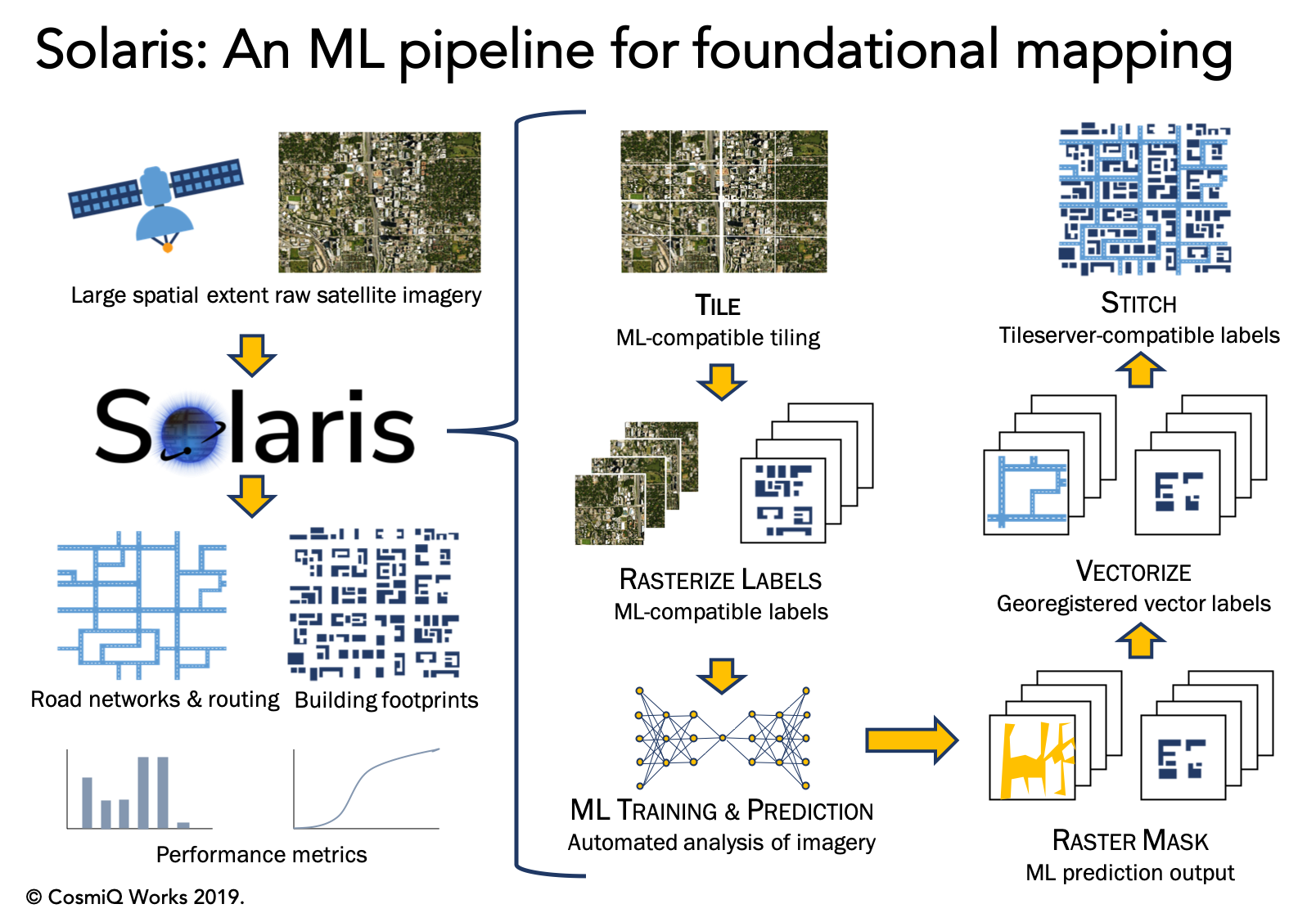
Solaris builds upon SpaceNet’s previous tool suite, SpaceNetUtilities, along with several other CosmiQ projects like BASISS to provide an end-to-end pipeline for geospatial AI. Solaris provides well-documented Python APIs and simple command line tools to complete every step of a geospatial ML pipeline with ease, including:

  • Tile raw imagery and vector labels into pieces compatible with ML
  • Convert vector labels to ML-compatible pixel masks
  • Train state-of-the-art deep learning models with three lines of Python code
  • Segment objects of interest with machine learning models (including the SpaceNet winners’ models, with pre-trained weights and configs provided!)
  • Georegister predictions and convert them to standardized geospatial data formats
  • Score model performance against hand-labeled ground truth using the SpaceNet datasets

Extensive documentation and tutorials are available for Solaris on the documentation page and on GitHub. The open source codebase is available under an Apache 2.0 license.

RELATED POSTS

  • Introducing the Solaris Multimodal Preprocessing Library

  • Solaris Model Deployment: From Start to Finish

  • Accelerating your geospatial deep learning pipeline with fine-tuning
  • Beyond Infrastructure Mapping — Finding Vehicles with Solaris
  • Announcing Solaris: an open source Python library for analyzing overhead imagery with machine learning
GITHUB

Filed Under: Archived Projects Tagged With: advisory, software

Machine Learning Robustness Study

July 1, 2019 by rocky

Machine Learning Robustness Study

SEE ALL PROJECTS

Within the broader computer vision community, the issue of dataset size has received surprisingly little attention. Most analyses simply use all available data and focus on model architecture, with scant attention given to whether the dataset size is appropriate for the task and architecture’s complexity.

Many different variables determine the ultimate mission impact of satellite imagery, a concept CosmiQ has referred to as the Satellite Utility Manifold. Previous CosmiQ studies have explored such variables as sensor resolution (0.3 meter to 2.4 meter), super-resolution techniques, and the number of imaging bands (grayscale versus multispectral).

Expanding on this work, the Machine Learning Robustness Study focuses on training dataset size and diversity on building detection performance in the SpaceNet data. The recent availability of this extensive dataset and model-building capability will make it possible to address dependence on geography and dataset size at the leading edge of geospatial machine learning.

RELATED POSTS

  • Predicting the Effect of More Training Data, by Using Less

  • Robustness of Limited Training Data: Part 5
  • Robustness of Limited Training Data: Part 4
  • Robustness of Limited Training Data: Part 3
  • Robustness of Limited Training Data: Part 2
  • Robustness of Limited Training Data for Building Footprint Identification: Part 1

Filed Under: Archived Projects Tagged With: advisory, models

Super-Resolution Trade Study

June 1, 2019 by rocky

Super-Resolution Trade Study

Quantifying the Effects of Super-Resolution on Object Detection Performance in Satellite Imagery

SEE ALL PROJECTS

At the inception of this research, the interplay between super-resolution techniques and object detection frameworks remained largely unexplored, particularly in the context of satellite or overhead imagery. Intuitively, super-resolution methods should increase object detection performance, as an increase in resolution should add more distinguishable features that an object detection algorithm can use for discrimination.

This trade study strived to answer these foundational questions:

  • Does the application of a super-resolution (SR) technique affect the ability to detect small objects in satellite imagery?
  • Across what resolutions are these SR techniques effective?
  • What is an ideal or minimum viable resolution for object detection?
  • Can one artificially double or even quadruple the native resolution of coarser imagery to make the data more useful and increase the ability to detect fine objects?

Our results showed that the application of SR techniques as a pre-processing step provided a statistically significant improvement in object detection performance in the finest resolutions.  For both object detection frameworks, the greatest benefit is achieved at the highest resolutions, as super-resolving native 30 cm imagery to 15 cm yields a 13−36% improvement in mean average precision. Furthermore, when using YOLT, we find that enhancing imagery from 60 cm to 15 cm provides a significant boost in performance over both the native 30 cm imagery (+13%) and native 60 cm imagery (+20%).

RELATED POSTS

  • Super-Resolution and Object Detection: A Love Story- Epilogue
  • Super-Resolution and Object Detection: A Love Story- Part 4
  • Super-Resolution and Object Detection: A Love Story- Part 3
  • Super-Resolution and Object Detection: A Love Story – Part 2
  • Super-Resolution and Object Detection: A Love Story – Part 1
  • The Effects of Super-Resolution on Object Detection Performance in Satellite Imagery

Filed Under: Archived Projects Tagged With: advisory, models

Satellite Communications Market Report

March 27, 2019 by rocky

Satellite Communications Market Report

SEE ALL PROJECTS

Emerging technical and business trends in the commercial satellite communication (“satcom”) market could impact how both commercial and governmental institutions use and invest in space-based communications services in the coming years. Historically, the relatively staid nature of the commercial satcom market has allowed for public and private sector organizations alike to plan for and acquire communications services years in advance. This consistency and development pace has been essential for a majority of the stakeholders involved ranging from regulators, financial institutions, and manufacturers. Looking ahead, commercial satcom operators in geostationary orbit (GSO) and non-geostationary orbit (NGSO), as well as their associated resellers, will likely experience some difficulty maintaining an equivalent level of service stability (and predictability) due to the following market trends:

  • New market entrants pursuing development of new low earth orbit (LEO) constellations at an unprecedented scale
  • Technical advancements in service delivery mediums
  • Increasing competition from terrestrial-based services
  • Emerging challenges to historical spectrum rights

These market changes present both challenges and opportunities for leaders in the public and private sector, and this project sought unpack some of these market trends and make several recommendations to market stakeholders.

Filed Under: Archived Projects Tagged With: advisory

Comet Time Series (TS)

February 27, 2019 by rocky

Comet Time Series (TS)

SEE ALL PROJECTS

A Software Package to Facilitate Time-Series Analysis of Satellite Imagery

Comet Time Series (CometTS) is a software package and tool that enables workflows for the analysis and visualization of a time series of satellite imagery for the data science and geographic science communities. The tool aims to enable population estimation research, land use change detection, or natural disaster monitoring using a range of data types. CometTS calculates relevant statistical quantities (e.g., measures of central tendency and variation) and provides a visualization of their changes over time. The package can help to serve as a rapid inspection workflow and analyze multiple regions of interest (ROI)’s in seconds.

CometTS has been employed to monitor electrical and infrastructure recovery in Puerto Rico following Hurricane Maria. For this study, the tool was used to extract the change in average nighttime brightness for all census tracts within Puerto Rico and to infer the number of persons without power over time. Multiple opportunities exist to employ CometTS for impactful work in the future including:

  • Population dynamics
  • Land-use change
  • Investigating seasonal or climatic conditions such as drought

Visualizations and analyses derived from CometTS in these topics can inform better understanding of changes to climate, poverty, food security, biodiversity, political conflict, and civil instability.

A visualization of mean observed brightness before and after Hurricane Maria in the San Juan Municipio, Puerto Rico. The linear regression forecast, and seasonal adjusted forecast are plotted in teal and orange respectively. Differences of observed vs. expected brightness can be visualized and quantified.

Related Posts

  • Comet Time Series (CometTS): a New Tool for Analyzing a Time-Series of Satellite Imagery
  • Puerto Rico: Electrical & Infrastructure recovery post-Maria
  • Comet Time Series Visualizer: CometTS
GITHUB

Filed Under: Archived Projects Tagged With: advisory, software

Commercial Remote Sensing Market Analysis

August 27, 2018 by rocky

Commercial Remote Sensing Market Analysis

SEE ALL PROJECTS

The rapid growth in commercial space startup activity, commonly referred to as Space 3.0, led to numerous claims about the potential size and growth trajectory of the satellite remote sensing market. Many of the optimistic market projections were largely based on the assumption that both startups and incumbents could derive unique and valuable insights from low-cost, frequently collected remote sensing data using emerging, advanced analytics techniques such as artificial intelligence specifically computer vision. Over the past several years, venture capitalists have invested in a diverse array of space startups ranging from rockets to payloads to data analytics companies. As the Space 3.0 startup market matured, we wanted to explore whether those market projections held true given the market developments over the last few years. Thus, CosmiQ conducted a comprehensive analysis of the commercial space remote sensing market to quantify market trends as well as analyze and project investment trends.

Filed Under: Archived Projects Tagged With: advisory

  • Go to page 1
  • Go to page 2
  • Go to Next Page »
  • Projects
  • Podcasts
  • Blog
  • Resources
  • About

  • Copyright © 2019 · IQT Labs LLC - All Rights Reserved | Terms of Use | Privacy Policy

We use cookies to analyze the usage of our websites and give you a better experience. You consent to our cookies if you click on “Agree” and continue to use our website. Read our Privacy Policy for more information and to know how to amend your settings.AgreePrivacy policy