• Skip to main content
CosmiqWorks
  • cosmiqworks-logo-r@2x
  • Projects
  • Blog
  • Podcasts
  • Resources
  • About
  •         

software

CRESI

January 18, 2020 by christynz

City-Scale Road Extraction from Satellite Imagery (CRESI)

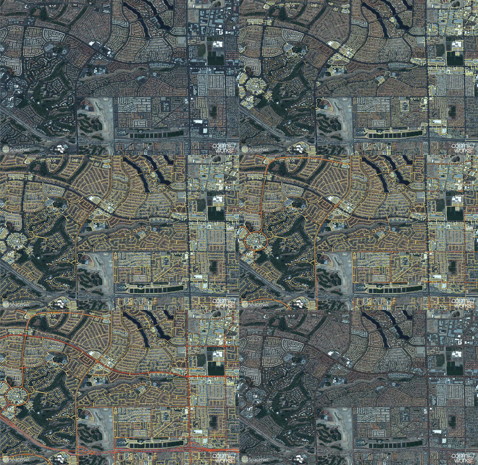
Rapidly extracts large scale road networks and identifies speed limits and route travel times for each roadway
SEE ALL PROJECTS

Optimized routing is crucial to a number of challenges, from humanitarian to military. Satellite imagery may aid greatly in determining efficient routes, particularly in cases involving natural disasters or other dynamic events where the high revisit rate of satellites may be able to provide updates far more quickly than terrestrial methods.  Existing data collection methods such as manual road labeling or aggregation of mobile GPS tracks are currently insufficient to properly capture either underserved regions (due to infrequent data collection), or the dynamic changes inherent to road networks in rapidly changing environments.

Our City-Scale Road Extraction from Satellite Imagery (CRESI) algorithm served as the baseline for SpaceNet 5, and rapidly extracts large scale road networks and identifies speed limits and route travel times for each roadway.  Including estimates for travel time permits true optimal routing (rather than just the shortest geographic distance), which is not possible with existing remote sensing imagery based methods.

Our code is publicly available at github.com/CosmiQ/cresi.

RELATED POSTS

  • City-Scale Road Extraction from Satellite Imagery v2_Road Speeds and Travel Times
  • Road Network and Travel Time Extraction from Multiple Look Angles with SpaceNet Data

  • Time-optimized Evacuation Scenarios Via Satellite Imagery
  • Road Network and Travel Time Extraction from Multiple Look Angles with SpaceNet Data
  • Computer Vision With OpenStreetMap and SpaceNet — A Comparison
  • Inferring Route Travel Times with SpaceNet
  • Extracting Road Networks at Scale with SpaceNet
GITHUB

Filed Under: Archived Projects Tagged With: models, software

SpaceNet 6

November 11, 2019 by rocky

SpaceNet 6

Multimodal Data Analysis for Travel Routing and Time Estimation

SEE ALL PROJECTS

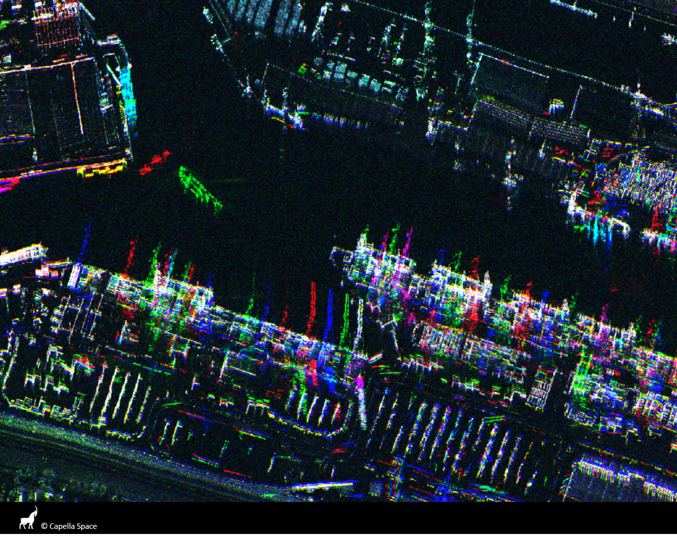
Synthetic Aperture Radar (SAR) is a unique form of radar that can penetrate clouds, collect during all- weather conditions, and capture data day and night. Overhead collects from SAR satellites could be particularly valuable in the quest to aid disaster response in instances where weather and cloud cover can obstruct traditional electro-optical sensors. However, despite these advantages, there is limited open data available to researchers to explore the effectiveness of SAR for such applications, particularly at ultra-high resolutions.

The task of SpaceNet 6 is to automatically extract building footprints with computer vision and artificial intelligence (AI) algorithms using a combination of SAR and electro-optical imagery datasets. This openly-licensed dataset features a unique combination of half-meter Synthetic Aperture Radar (SAR) imagery from Capella Space and half-meter electro-optical (EO) imagery from Maxar’s WorldView 2 satellite. The area of interest for this challenge will be centered over the largest port in Europe: Rotterdam, the Netherlands. This area features thousands of buildings, vehicles, and boats of various sizes, to make an effective test bed for SAR and the fusion of these two types of data.

In this challenge, the training dataset contains both SAR and EO imagery, however, the testing and scoring datasets contain only SAR data. Consequently, the EO data can be used for pre-processing the SAR data in some fashion, such as colorization, domain adaptation, or image translation, but cannot be used to directly map buildings. The dataset is structured to mimic real-world scenarios where historical EO data may be available, but concurrent EO collection with SAR is often not possible due to inconsistent orbits of the sensors, or cloud cover that will render the EO data unusable.

Learn More

RELATED POSTS

  • SpaceNet 6: Expanded Dataset Release

  • SpaceNet 6: Winning Model Release

  • SpaceNet 6: Data Fusion and Colorization

  • SpaceNet 6: Exploring Foundational Mapping at Scale

  • SpaceNet 6: Announcing the Winners

  • SpaceNet 6 Challenge Launch

  • The SpaceNet 6 Baseline

  • SAR 201: An Introduction to Synthetic Aperture Radar, Part 2

  • SAR 101: An Introduction to Synthetic Aperture Radar

  • SpaceNet 6: Dataset Release

  • Announcing SpaceNet 6: Multi-Sensor All Weather Mapping

Filed Under: Archived Projects Tagged With: datasets, models, software

Solaris

September 1, 2019 by rocky

Solaris

An open source Python library for analyzing overhead imagery with machine learning

SEE ALL PROJECTS

Performing machine learning (ML) and analyzing geospatial data are both hard problems requiring a lot of domain expertise. These limitations have historically meant that one needs to be an expert in both to perform even the most basic analyses, making advances in AI for overhead imagery difficult to achieve. We asked ourselves: is there anything we can do to reduce this barrier to entry, making it easier to apply machine learning methods to overhead imagery data? Enter Solaris, a new Python library for ML analysis of geospatial data.

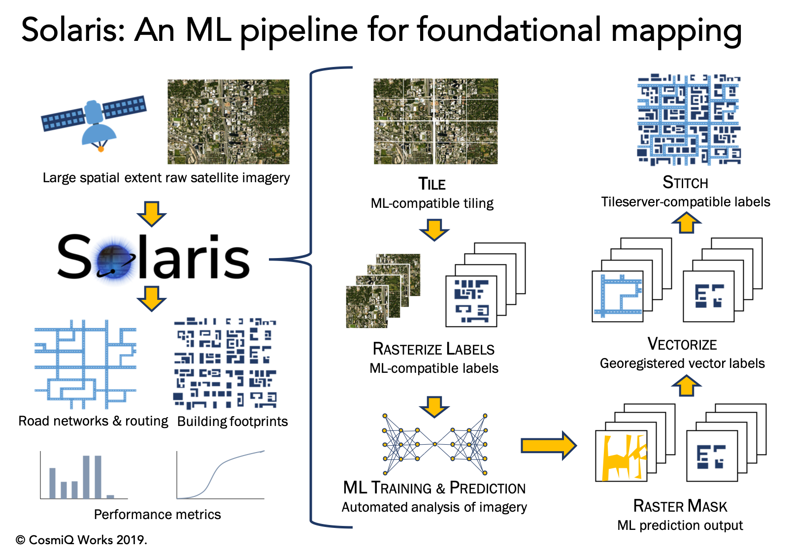
Solaris builds upon SpaceNet’s previous tool suite, SpaceNetUtilities, along with several other CosmiQ projects like BASISS to provide an end-to-end pipeline for geospatial AI. Solaris provides well-documented Python APIs and simple command line tools to complete every step of a geospatial ML pipeline with ease, including:

  • Tile raw imagery and vector labels into pieces compatible with ML
  • Convert vector labels to ML-compatible pixel masks
  • Train state-of-the-art deep learning models with three lines of Python code
  • Segment objects of interest with machine learning models (including the SpaceNet winners’ models, with pre-trained weights and configs provided!)
  • Georegister predictions and convert them to standardized geospatial data formats
  • Score model performance against hand-labeled ground truth using the SpaceNet datasets

Extensive documentation and tutorials are available for Solaris on the documentation page and on GitHub. The open source codebase is available under an Apache 2.0 license.

RELATED POSTS

  • Introducing the Solaris Multimodal Preprocessing Library

  • Solaris Model Deployment: From Start to Finish

  • Accelerating your geospatial deep learning pipeline with fine-tuning
  • Beyond Infrastructure Mapping — Finding Vehicles with Solaris
  • Announcing Solaris: an open source Python library for analyzing overhead imagery with machine learning
GITHUB

Filed Under: Archived Projects Tagged With: advisory, software

SIMRDWN

May 27, 2019 by rocky

Satellite Imagery Multiscale Rapid Detection with Windowed Networks (SIMRDWN) Repository

SEE ALL PROJECTS

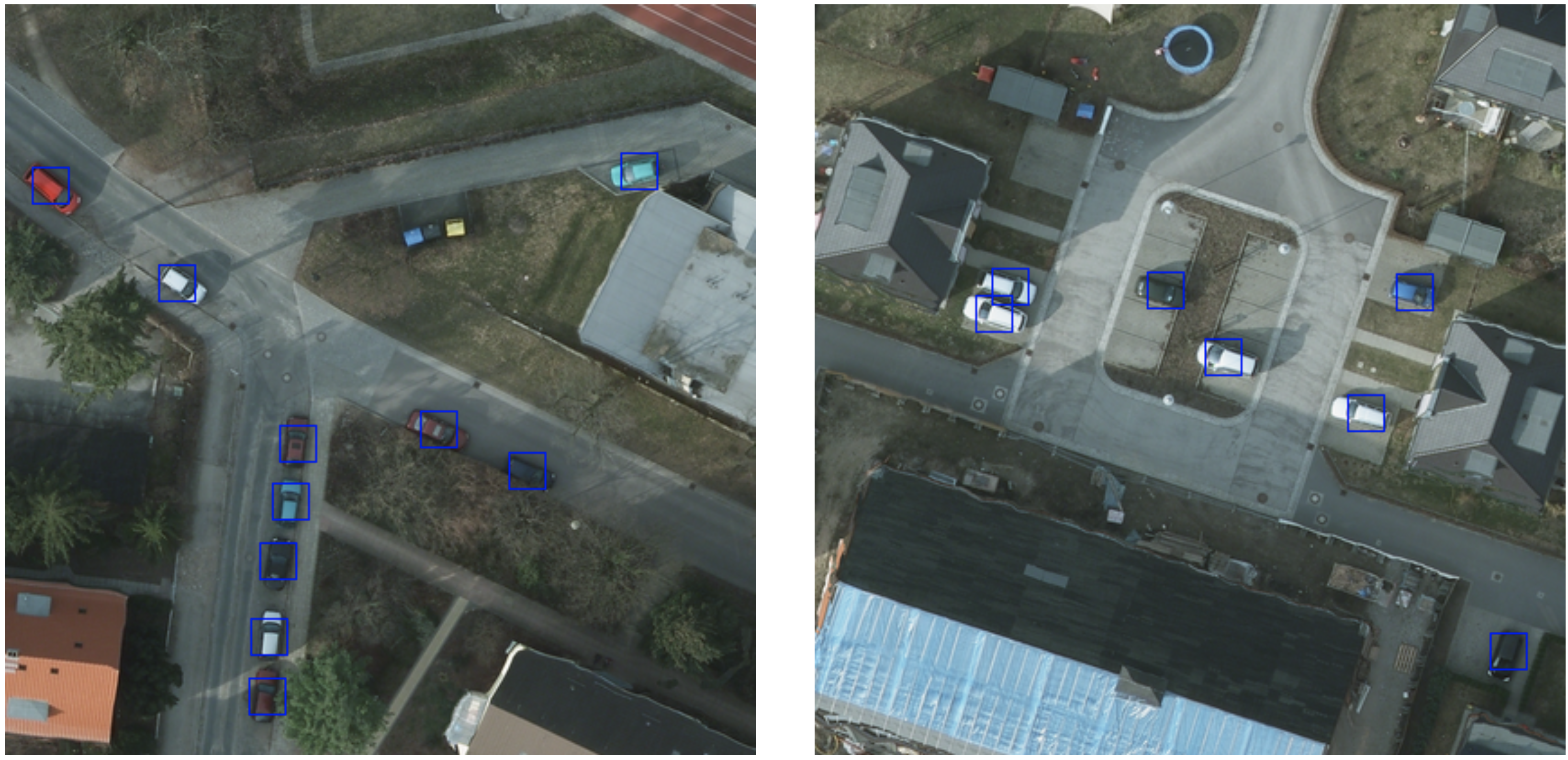
Rapid detection of small objects over large areas remains one of the principal drivers of interest in satellite imagery analytics. This project sought to build off our previous work with the You Only Look Twice (YOLT) algorithm, which modified YOLO to rapidly analyze images of arbitrary size, and improves performance on small, densely packed objects.

Since YOLO is just one of many advanced object detection frameworks, however, and algorithms such as SSD, Faster R-CNN, and R-FCN merit investigation against geospatial applications as well, CosmiQ developed the Satellite Imagery Multiscale Rapid Detection with Windowed Networks (SIMRDWN) framework. SIMRDWN (phonetically: [SIM-er] [doun]) combined the scalable code base of YOLT with the TensorFlow Object Detection API, allowing end users to select a vast array of architectures to apply towards bounding box detection of objects in overhead imagery.

Related Posts

  • SIMRDWN: Adapting Multiple Object Detection Frameworks for Satellite Imagery Applications
  • Giving SIMRDWN a Spin, Part II
  • Giving SIMRDWN a Spin, Part I
  • Satellite Imagery Multiscale Rapid Detection with Windowed Networks

GITHUB

Filed Under: Archived Projects Tagged With: models, software

Comet Time Series (TS)

February 27, 2019 by rocky

Comet Time Series (TS)

SEE ALL PROJECTS

A Software Package to Facilitate Time-Series Analysis of Satellite Imagery

Comet Time Series (CometTS) is a software package and tool that enables workflows for the analysis and visualization of a time series of satellite imagery for the data science and geographic science communities. The tool aims to enable population estimation research, land use change detection, or natural disaster monitoring using a range of data types. CometTS calculates relevant statistical quantities (e.g., measures of central tendency and variation) and provides a visualization of their changes over time. The package can help to serve as a rapid inspection workflow and analyze multiple regions of interest (ROI)’s in seconds.

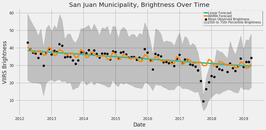
CometTS has been employed to monitor electrical and infrastructure recovery in Puerto Rico following Hurricane Maria. For this study, the tool was used to extract the change in average nighttime brightness for all census tracts within Puerto Rico and to infer the number of persons without power over time. Multiple opportunities exist to employ CometTS for impactful work in the future including:

  • Population dynamics
  • Land-use change
  • Investigating seasonal or climatic conditions such as drought

Visualizations and analyses derived from CometTS in these topics can inform better understanding of changes to climate, poverty, food security, biodiversity, political conflict, and civil instability.

A visualization of mean observed brightness before and after Hurricane Maria in the San Juan Municipio, Puerto Rico. The linear regression forecast, and seasonal adjusted forecast are plotted in teal and orange respectively. Differences of observed vs. expected brightness can be visualized and quantified.

Related Posts

  • Comet Time Series (CometTS): a New Tool for Analyzing a Time-Series of Satellite Imagery
  • Puerto Rico: Electrical & Infrastructure recovery post-Maria
  • Comet Time Series Visualizer: CometTS
GITHUB

Filed Under: Archived Projects Tagged With: advisory, software

  • Projects
  • Podcasts
  • Blog
  • Resources
  • About

  • Copyright © 2019 · IQT Labs LLC - All Rights Reserved | Terms of Use | Privacy Policy

We use cookies to analyze the usage of our websites and give you a better experience. You consent to our cookies if you click on “Agree” and continue to use our website. Read our Privacy Policy for more information and to know how to amend your settings.AgreePrivacy policy